Kaupo
Kaupo is one of the districts of ancient Hawaii (moku in the Hawaiian language) of Maui island in Hawaii. Kaupo is a very remote and sparsely populated sustainable ranching community.
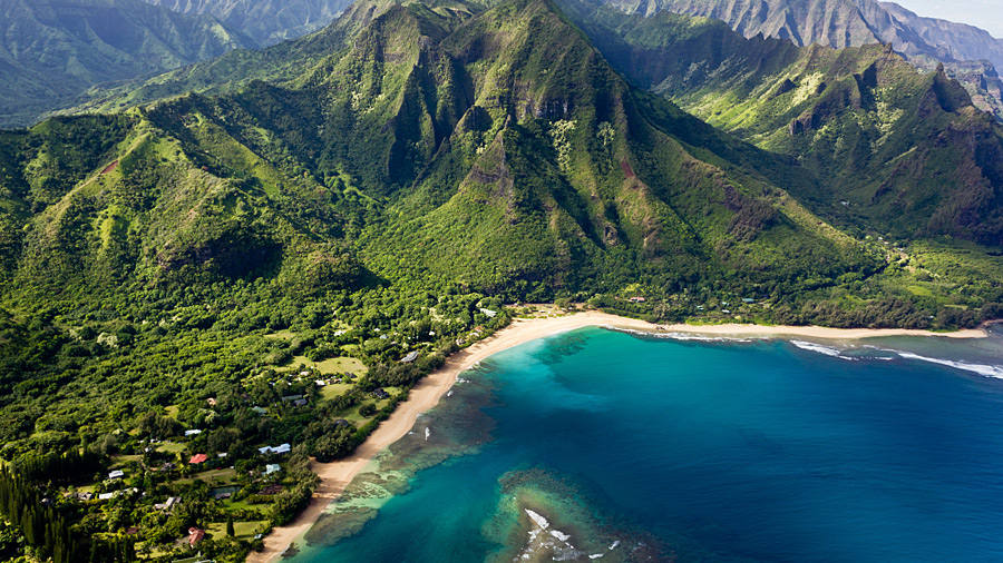
Kaupo is located along the southeastern shore of Maui, west of Kipahulu along the Kahikinui coastline. Kaupo is located on a very rugged and desolate side of the island. The Kahikinui Forest Reserve is located in the area, as well as a section of Haleakalā National Park. A trail leads from near the summit of Haleakalā through Kaupo Gap.
Kaupo is connected to the rest of the island via the Pi’ilani Highway (Hawaii Route 31). The highway is primarily one lane wide and is not paved in all sections.
Napali
Nāpili-Honokōwai is a census-designated place (CDP) in Maui County, Hawaiʻi, United States. The population was 7,261 at the 2010 census.
Nāpili-Honokōwai is located at 20°58′1″N 156°40′14″W (20.966949, -156.670672),[2] between the communities of Kapalua to the north and Kaanapali to the south. It consists of three separate neighborhoods (from north to south) Nāpili, Kahana, and Honokōwai.
According to the United States Census Bureau, the CDP has a total area of 4.3 square miles (11.1 km2), of which 2.6 square miles (6.8 km2) is land and 1.7 square miles (4.3 km2), or 38.35%, is water.
Makawao
Makawao is a census-designated place (CDP) in Maui County, Hawai'i, United States. The population was 7,184 at the 2010 census.[1] Located on the rural northwest slope of Haleakala on East Maui, the community is known for being the hub of the "Upcountry", a part of the island dominated by mostly agriculture and ranch land.
Makawao is located at 20°51′13″N 156°19′1″W (20.853657, -156.316951).
According to the United States Census Bureau, the CDP has a total area of 3.5 square miles (9.0 km2), all of it land.
Keokea
Kēōkea is an unincorporated community on the island of Maui in Maui County, Hawaii, United States. It is situated on Hawaii State Highway 37 (the Kula Highway) at North Latitude 20.71 degrees, West Longitude 156.36 degrees. Its elevation is 2,860 feet (260 meters) above sea level. Agriculture, forestry and ranching—supported by the area’s fertile though often rocky volcanic loams [1]—are important around this settlement, which has a temperate climate because of its elevation. Tourism also contributes to the local economy. The area around Keokea is characterized by a steep precipitation gradient: lowlands just 5 miles (8.0 km) to the northwest have mean annual precipitation of less than 16 inches (410 mm), while higher elevations ten miles (16 km) to the northeast see 140 inches (3,600 mm). Keokea has a mean annual precipitation of about 32 inches (810 mm). The population was 1,612 at the 2010 Census.
Pauwela
Haiku-Pauwela is a census-designated place (CDP) in Maui County, Hawaii, United States. The population was 8,118 at the 2010 census.
Haiku-Pauwela is located at 20°55’14?N 156°18’45?W (20.920528, -156.312631).
According to the United States Census Bureau, the CDP has a total area of 19.2 square miles (49.6 km2), of which 15.8 square miles (40.9 km2) is land and 3.4 square miles (8.8 km2), or 17.67%, is water.
Olowalu
Olowalu is a community on the west side of the island of Maui in the state of Hawaii. It is located about 4 miles (6.4 km) south of Lahaina on the Honoapiʻilani Highway.
It sustained a large population, governed by the high chiefess Kalola, daughter of Maui ruler Kekaulike, and grandmother of Keopuolani. It was home to a traditional farming community until the arrival of the Europeans, who replaced it with a sugarcane plantation. The massacre in 1790 described below, as well as the labor-hungry sandalwood trade, contributed to the site’s decline. A substantial real estate development is under consideration for the area. The area is home to one of Hawaii’s most striking reefs.
From ancient times, Olowalu was considered a place of refuge, or pu'u honua, by Hawaiians. Persons pursued for committing an offense against a family group or an ali'i (royal) were untouchable once they stepped inside its borders. Violating sanctuary was punishable by death. For Pacific Island cultures, maintaining a peaceful order was a deep cultural tenet. For people on Maui, Olowalu created an interval of space and time to resolve disputes.
Launiupoko
Launiupoko is an unincorporated community and census-designated place on the island of Maui in Maui County, Hawaii, United States. Its population was 588 as of the 2010 census. The community is located on the west side of the island.
Launiupoko is located at 20.8499992°N 156.6376421°W. According to the U.S. Census Bureau, the community has an area of 5.333 square miles (13.81 km2), of which 5.327 square miles (13.80 km2) is land and 0.006 square miles (0.016 km2) is water.
Kula
Kula is a district of Maui, Hawaii, that stretches across the "up-country", the western-facing slopes of Haleakalā, from Makawao to Ulupalakua. Most of the residential areas lie between about 500 to 1,100 m (1,600 to 3,600 ft) in elevation. The district has traditionally been where full-time residents prefer to live, as distinct from the generally hotter and busier, more tourism-oriented towns near sea level, such as Kihei and Lahaina. The population of the census-designated place (CDP) at the 2010 Census was 6,452.
Kula roughly extends from Haleakala Highway (Hawaii Route 37) in the north to Keokea in the south—a distance of about 16 miles. The largely rural area known as Upper Kula includes the region up-slope from Lower Kula, the more densely populated area spread along the Kula Highway.
The word Kula means "open meadows" in the Hawaiian language. On Maui Kula is one of the island’s 12 foundation districts of ancient Hawaii called moku. Generally, Kula is a zone of arid earth with open country slopes between the inhabited and productive shoreline areas and the densely forested zone higher on the mountain.
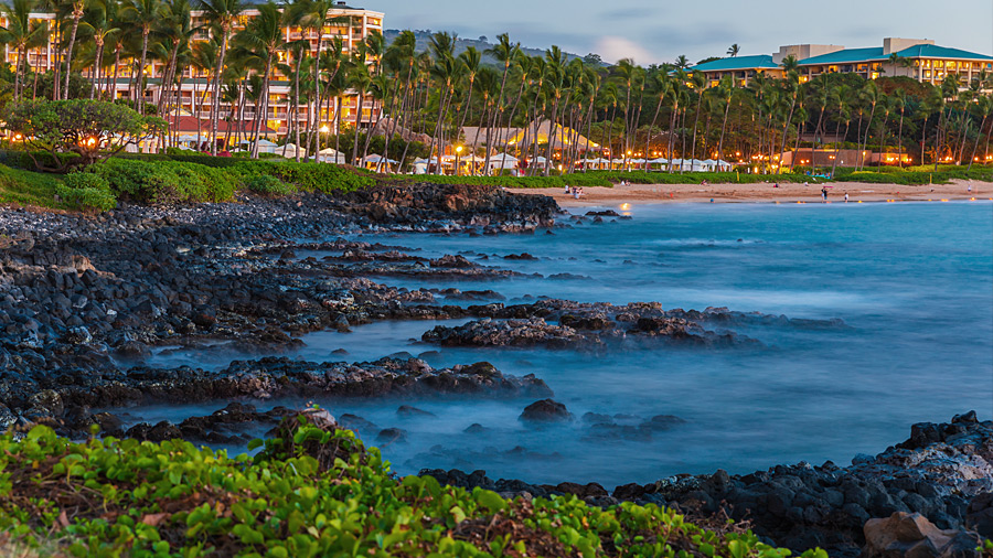
Kaanapali
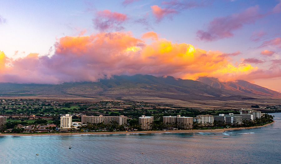
Kā'anapali is a census-designated place (CDP) in Maui County, Hawai'i, United States. The population was 1,250 at the 2010 census.[1] The master-planned town is located in the Old Hawaii ahupuaa of Hanakaʻōʻō, as in the same name of the southern end of Kaanapali Beach’s Hanakaʻōʻō Canoe Beach.
Kā'anapali is located at 20°56'5"N 156°40'46"W (20.934820, -156.679329).
According to the United States Census Bureau, the CDP has a total area of 6.3 square miles (16.3 km2), of which 4.9 square miles (12.8 km2) is land and 1.3 square miles (3.4 km2), or 21.19%, is water.
Wailea
Wailea is a census-designated place (CDP) in Maui County, Hawai'i, United States. As of the 2010 census, it had a population of 5,938. Prior to 2010, the area was part of the Wailea-Makena census-designated place. The community was developed in 1971 by a partnership of Alexander & Baldwin and Northwestern Mutual.
According to the United States Census Bureau, the CDP has a total area of 10.7 square miles (27.8 km2), of which 7.5 square miles (19.3 km2) is land and 3.3 square miles (8.5 km2), or 30.70%, is water.
Puunene
Pu'unene is an unincorporated community in the central part of Maui, Hawaii, near Kahului. Although the land in that area is fairly level, the words Pu'u nene mean "nene goose hill" in Hawaiian. With a population of around 50, Pu’unene’s primary industry is growing, harvesting and processing sugarcane.
The nonprofit Alexander & Baldwin Sugar Museum is housed in the former residence of the superintendent of Pu'unene Sugar Mill, which the Hawaiian Commercial & Sugar Company (a division of Alexander & Baldwin) has operated across the street since 1901. Its mission is “to preserve and present the history and heritage of Hawaii's sugar industry, and the multi-ethnic plantation life which it engendered." Also located in Puʻunēnē is the Pu'unene School, which is listed on the National Register of Historic Places.
Pu'unene's Zip code is 96784. The mill is located just east of Mokulele Highway, Hawaii Route 311.
About three miles to the south of Pu'unēnē is the site of a former Naval Air Station (1940–1947).An old runway is now used as a drag strip for Maui Raceway Park.
Paia
Pā'ia (pah-ee-ah) is a census-designated place (CDP) in Maui County, Hawai'i, on the northern coast of the island of Maui. The population was 2,668 at the 2010 census. Pā'ia is home to several restaurants, art galleries, surf shops and other tourist-oriented businesses. It was formerly home to a Hawaiian Commercial & Sugar mill from 1880 to 2000.
Pā'ia is the last town on the Hāna highway when heading eastbound towards Hāna.
Pa'ia is located close to many internationally known windsurfing spots including Ho’okipa and Spreckelsville. It is therefore sometimes called "The World Capital of Windsurfing".
Maalaea
Mā'alaea is a census-designated place (CDP) in Maui County, Hawai'i, United States. The population was 352 at the 2010 census. Mā'alaea is the site of a small boat harbor, as well as the Maui Ocean Center.
According to the United States Census Bureau, the CDP has a total area of 7.8 square miles (20.1 km2), of which 5.4 square miles (14.1 km2) is land and 2.3 square miles (6.0 km2), or 29.99%, is water.
Kihei
Kīhei is a census-designated place (CDP) in Maui County, Hawai'i, United States. The population was 20,881 at the 2010 census.
According to the United States Census Bureau, the CDP has a total area of 11.7 square miles (30.2 km2), of which 9.3 square miles (24.0 km2) is land and 2.4 square miles (6.2 km2), or 20.44%, is water.[3] It is considered to be the South Side of Maui, located on the leeward side of Haleakala. The climate is arid, receiving no more than 10 inches (250 mm) of rain per year.
Keanae
Keanae is an unincorporated community in Maui County on the island of Maui in the U.S. state of Hawaii. Ke'anae is a peninsula known best for being one of Hawaii’s major taro farm growing regions. Keanae shares the zip code of 96708 with Ha'iku.
Haiku
Haiku is an unincorporated community in Maui County on the island of Maui in the state of Hawaii. For United States Census purposes, it is part of the Haiku-Pauwela, Hawaii census-designated place, which also includes Pauwela.
It was named for the ancient Hawaiian land section of Ha'ikū, which means "talk abruptly" or "sharp break" in the Hawaiian language.
Lahaina
There are many different climates in the different districts of Lahaina. The historic district is the driest and calmest and hosts the small boat harbor. Kaanapali is north of a wind line and has double the annual rainfall and frequent breezes. The Kapalua and Napili areas have almost four times the annual rainfall compared to the historic district of Lahaina. The historic district has preserved 60 historic sites within a small area and they are managed by the Lahaina Restoration.
Lahaina was the capital of the Kingdom of Hawaii from 1820 to 1845, when the capital was moved back to Honolulu. In the 19th century, Lahaina was the center of the global whaling industry, with many sailing ships anchoring at its waterfront; today pleasure craft make their home there. Lahaina's Front Street has been ranked one of the "Top Ten Greatest Streets" by the American Planning Association.
Lahaina's popularity as a tropical getaway has made its real estate some of the most expensive in Hawaii; many luxury homes and condos are sold for more than $2 million there.
Haleakala
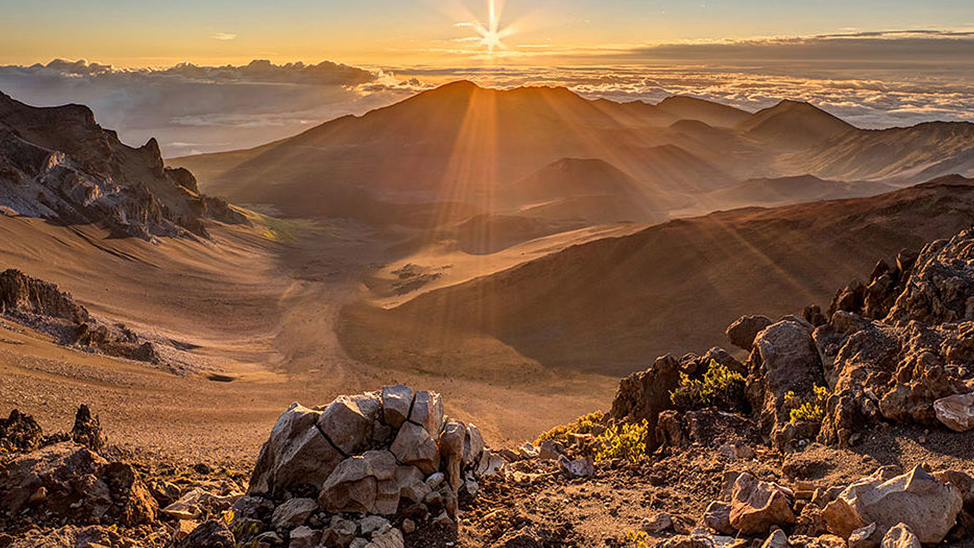
The landscape of Haleakala National Park rises from a lush valley beneath a waterfall at sea level to a red desert of cinder cones up at the volcanic summit of Haleakala. An astounding array of climates and life zones lies in between. Yet the park's many contrasting worlds are vitally linked. Rain that falls on the volcano's slopes and carves its valleys nourishes a multitude of life forms.
The land above the clouds, kua mauna, is a place where people never dwelled for long. Ka po'e kahiko, the people of old, only came to this sacred place for specific reasons requiring training and understanding. At the foot of the mountain lies kahakai, the coastal land, inhabited and cultivated for centuries. Haleakala National Park preserves and helps perpetuate the cultural richness of both kua mauna, kahakai, and the diverse features in between. It is all here for you to explore